

 Between the Los Angeles River, San Gabriel River, Los Coyotes Creek and numerous other creeks and culverts there are over forty miles of fortified waterways in Long Beach. Some were created for flood control having always been encased in concrete while others were natural waterways channelized to control their alluvial past. Returning the Los Angeles and San Gabriel Rivers to more natural forms has been discussed for at least a decade while the city’s more local tributaries have received little attention.
Naturalizing these waterways would not necessitate a return to their wild ways; instead many of these can become rivers, creeks and streams without impacting their flood control capabilities. This would require thoughtful engineering that looks beyond carrying capacity (how much water these drainages can hold) to include reductions in the need for stormwater drainage to prevent flooding, through more permeable road, parking and walkway surfaces and better on-site stormwater management practices. California has begun enacting regulations that in part address urban water run-off for new development, and the city is beginning to explore sustainable stormwater management strategies such as retention/detention facilities and bioswales integrated into infrastructure.
The pay-off of successfully managing stormwater run-off in the early stages is the potential return of nature to large portions of Long Beach. Imagine the addition of nearly a thousand acres of new open space, as concrete channels become greenbelts crisscrossing the city. This additional layer to Long Beach’s park network could provide open space for under-served communities, while connecting many more to larger regional scale parks.
Of the entire fifty-mile length of the Los Angeles River, it is at its widest between the 91 and 405 Freeways in Long Beach. From the edge of the 710 Freeway to the first property there is a quarter mile of flood control channel, Southern California Edison right-of-way and drainage basins. Like Santa Ana’s hundred-acre Riverview Park, Deforest Park in Long Beach can be expanded into the Los Angeles River’s Channel and SCE property to create an incredibly large seasonal park. In the rainy season the river can serve its primary purpose of urban stormwater management, but during the other nine months the area can provide up to five hundred acres of park space.
The convergence of Los Coyotes Creek and the San Gabriel River could provide an additional two hundred acres of open space to El Dorado Park. Going south, the combined waterway connects to Edison Park in Seal Beach before linking to the Los Cerritos Wetlands, creating a massive greenbelt along the entire eastern edge of Long Beach. The two river greenbelts would become amenities instead of just infrastructure, creating greater value for the communities they travel through. The naturalization of these large concrete bodies would filter stormwater, reduce the urban heat island effect, provide more vegetation to clean the air and more habitat for native insects, fish, birds and other wildlife.
The naturalization of two dozen miles of drainage channels throughout Long Beach’s Eastside would create another couple hundred acres of open space, while increasing the value of hundreds of properties flanking these waterways. Millions of dollars are being spent on subterranean stormwater mains along the Pacific Electric right of way, and millions more are being invested in new park space development above. Instead the resources could be spent to create a new creek cutting diagonally through the city connecting Colorado Lagoon to Long Beach’s new Central Park (described in Bold Idea #10) to the Los Angeles River Park.
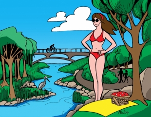
The bike paths along Los Angeles and San Gabriel Rivers could become part of a large pedestrian and bicycle freeway system as these grade-separated, naturalized viaducts weave throughout the city unfettered by automobile movement. These trails would build-upon the new bicycle infrastructure connecting communities, commerce and open space throughout the city with safe, efficient, alternative modes of transportation.
Naturalizing these waterways and drainage channels would require a significant reduction of stormwater, which could be accomplished with bioswales, retention/detention basins and greater overall surface permeability in the city. While this requires wholesale change in how public infrastructure is designed, it also needs property owners to manage their contributing stormwater run-off, from reducing paved surface areas of their lots to containing their structures’ roof drainage, either in cisterns or planted areas. Doing so would make possible the recreational use of our urban waterways and the reduction of the trash and pollution that reaches the Pacific Ocean.
Illustration by Andrew Wilson